
Round Howe
Tout fishing only, any legal method
This part of the river contains only trout therefore there is
NO FISHING from 1st October until 25th March.
Park at Round Howe public car park to access the north bank. Cross the footbridge to access the south bank. Alternatively walk in from bottom of the beat at the Green Bridge. Park on the Green or in York Square public car park.
Beat length approximately 2.9km (1.8 miles).
All fish to be returned unharmed.
Species
Brown Trout.
Map
Click the image above or the link below to view on Google Maps. Click on each peg number for W3W locations.
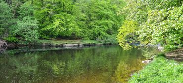
Round howe footbridge, downstream
.jpg/:/rs=w:370,cg:true,m)
.jpg/:/rs=w:370,cg:true,m)
.jpg/:/rs=w:370,cg:true,m)
.jpg/:/rs=w:370,cg:true,m)
.jpg/:/cr=t:0%25,l:0%25,w:100%25,h:100%25/rs=w:370,cg:true)
.jpg/:/cr=t:0%25,l:0%25,w:100%25,h:100%25/rs=w:370,cg:true)
.jpg/:/cr=t:0%25,l:0%25,w:100%25,h:100%25/rs=w:370,cg:true)
Round howe woods
.jpg/:/cr=t:0%25,l:0%25,w:100%25,h:100%25/rs=w:370,cg:true)
.jpg/:/cr=t:0%25,l:0%25,w:100%25,h:100%25/rs=w:370,cg:true)
.jpg/:/cr=t:0%25,l:0%25,w:100%25,h:100%25/rs=w:370,cg:true)
.jpg/:/cr=t:0%25,l:0%25,w:100%25,h:100%25/rs=w:370,cg:true)
.jpg/:/cr=t:0%25,l:0%25,w:100%25,h:100%25/rs=w:370,cg:true)
billy bank wood
.jpg/:/cr=t:0%25,l:0%25,w:100%25,h:100%25/rs=w:370,cg:true)
.jpg/:/cr=t:0%25,l:0%25,w:100%25,h:100%25/rs=w:370,cg:true)
.jpg/:/cr=t:0%25,l:0%25,w:100%25,h:100%25/rs=w:370,cg:true)
.jpg/:/cr=t:0%25,l:0%25,w:100%25,h:100%25/rs=w:370,cg:true)
.jpg/:/cr=t:0%25,l:0%25,w:100%25,h:100%25/rs=w:370,cg:true)
.jpg/:/cr=t:0%25,l:0%25,w:100%25,h:100%25/rs=w:370,cg:true)
Footbridge to Lowenthwaite Bridge (Hudswell Woods / Hudswell Bank)


.jpg/:/rs=w:370,cg:true,m)
.jpg/:/rs=w:370,cg:true,m)
.jpg/:/cr=t:0%25,l:16.22%25,w:67.56%25,h:67.56%25/rs=w:370,cg:true,m)
.jpg/:/rs=w:370,cg:true,m)
.jpg/:/cr=t:0%25,l:16.22%25,w:67.56%25,h:67.56%25/rs=w:370,cg:true,m)
.jpg/:/cr=t:0%25,l:15.39%25,w:69.22%25,h:69.22%25/rs=w:370,cg:true,m)
Top limit, approaching Lowenthwaite bridge via Hudswell Bank / Hudswell Wood
.jpg/:/rs=w:370,cg:true,m)
.jpg/:/rs=w:370,cg:true,m)
.jpg/:/cr=t:0%25,l:0%25,w:100%25,h:100%25/rs=w:370,cg:true)
.jpg/:/cr=t:0%25,l:0%25,w:100%25,h:100%25/rs=w:370,cg:true)
.jpg/:/cr=t:0%25,l:0%25,w:100%25,h:100%25/rs=w:370,cg:true)
.jpg/:/cr=t:0%25,l:0%25,w:100%25,h:100%25/rs=w:370,cg:true)