Richmond & District Angling Society

Call or Text 07742 300881

  • Home
  • Contact
  • Membership
  • Day Permits
  • Beat Maps
  • Rules
  • Report
  • Catch Returns
  • News
  • Get Involved
  • What's On
  • Articles
  • Gallery
  • River Levels
  • Safety
  • Useful Links
  • Constitution
  • Clubmate
  • Sitemap
  • Policies and Procedures
  • Awards
  • Club Events
  • Exchange Tickets
  • Biosecurity
  • D'Arcy Hildyard Water
  • D'Arcy Hildyard Lakes
  • More
    • Home
    • Contact
    • Membership
    • Day Permits
    • Beat Maps
    • Rules
    • Report
    • Catch Returns
    • News
    • Get Involved
    • What's On
    • Articles
    • Gallery
    • River Levels
    • Safety
    • Useful Links
    • Constitution
    • Clubmate
    • Sitemap
    • Policies and Procedures
    • Awards
    • Club Events
    • Exchange Tickets
    • Biosecurity
    • D'Arcy Hildyard Water
    • D'Arcy Hildyard Lakes

Call or Text 07742 300881

Richmond & District Angling Society
  • Home
  • Contact
  • Membership
  • Day Permits
  • Beat Maps
  • Rules
  • Report
  • Catch Returns
  • News
  • Get Involved
  • What's On
  • Articles
  • Gallery
  • River Levels
  • Safety
  • Useful Links
  • Constitution
  • Clubmate
  • Sitemap
  • Policies and Procedures
  • Awards
  • Club Events
  • Exchange Tickets
  • Biosecurity
  • D'Arcy Hildyard Water
  • D'Arcy Hildyard Lakes

Broken Brae

A very short section of water with tricky access down a steep river bank. Two pegs offer good coarse fishing for those who persevere. Some big grayling and chub have been caught.

Broken Brae Beat

Coarse Fishing

Any legal method allowed. All fish to be returned unharmed. 


Beat length approximately 190m (0.1 miles).


Species

Trout, Grayling, Chub, Barbel, Dace, Pike.


Fly fishing

It is possible to stand at the edge and roll cast in low water conditions with care. This is NOT recognised fly water.


Coarse Fishing

Difficult access and tricky casting on a steep tree lined river bank. 

Map

Click the image above or the link below to view on Google Maps. Click on each peg number for W3W locations. 

Google Maps

Broken Brae: Pegs 21 to 22

Parking

Parking in the lay-by in front of the Millbry Hill outdoor store on the B6271. 

what3words reference: selection.boil.poetic


Cross the road where the fence ends and follow the path upstream or downstream.

Peg 21

This is the top of peg 21. The banks here are very steep and access should be approached with great care, especially in slippery conditions. There are also areas of deep water close to the bank, which provide cover for chub and faster water is good for trout and grayling.

what3words reference: 

regulates.lawn.notebook

Peg 21B

Peg 21B

Peg 21B has been added with a platform and a wooden frame to assist with access. Great care still needs to be taken when accessing!
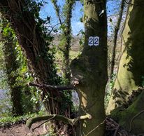
Peg 22

Peg 21B

The actual peg is facing the road, so you will not see it is you are walking the bank looking towards the river. Again, very steep bank that needs to be approached with care - see next photo. 

what3words reference: scaffold.breathed.bloodshot

Peg 22: Access

The blue rope has been added to assist access to peg 22.


It is steep and there is deep water at the near bank, so great care needs to be taken!

Collapsed Bank

Just after the start of Peg 22, this shows the power of the Swale in flood and a reminder that banks can collapse at any time

Downstream Limit

Downstream Limit

Downstream Limit

The downstream limit is marked by this fence.

what3words reference: limits.dabbled.brew


Copyright © 2023 RADAS

  • Home
  • Contact
  • Beat Maps
  • Rules
  • Report
  • Catch Returns
  • River Levels
  • Safety
  • Constitution
  • About
  • Sitemap
  • Fish Welfare

Powered by

Cookie Policy

This website uses cookies. By continuing to use this site, you accept our use of cookies. Privacy Policy

DeclineAccept & Close